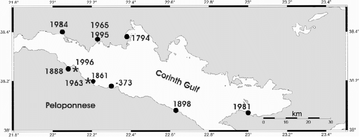
| Year | Day | Lat | Long | cause | intensity |
| -373 | winter | 38 11 | 22 09 | EL | 5/9 |
| 1794 | 11/6 | 38 23 | 22 23 | EL | 3/5 |
| 1861 | 26/12 | 38 12 | 22 12 | 3(+)/5 | |
| 1888 | 9/9 | 38 15 | 22 05 | 2/3 | |
| 1963 | 7/2 | 38 12 | 22 12 | 4/7 | |
| 1965 | 6/7 | 38 22 | 22 14 | EL | 3/5 |
| 1984 | 11/2 | 38 24 | EL | 3/4 | |
| 1995 | 15/6 | 38 22 | 22 14 | EL | 2(+)/4 |
| 1996 | 1/1 | 38 15 | 22 07 | GS | 3(+)/5 |
Main characteristics of the events from Papadopoulos (2003). EL = earthquake landslide, ES = earthquake marine slide, GS=gravitative marine slide. Tsunami intensity estimated in the 6-grade Sieberg-Ambraseys scale and the 12-grade Papadopoulos and Imamura (2001) scale.
-373 – Helike
Large earthquake with subsidence of the coastal strip of the Helike city, triggering a high tsunami. The city inundated while ten Spartan ships which happened to be at anchor close by destroyed along with the city.
11 June 1794 – Galaxidi
According to an anonymous manuscript written in c.1796, a tsunami was caused by coastal slump due to a strong earthquake near Galaxidi.
26 December 1861 – Valimitika
A large (M≥6.6) earthquake caused surface-breaks 13 km long, soil liquefaction and a coastal subsidence. Five tsunami waves, possibly caused by the coastal subsidence, were observed immediately after the shock with wave heights up to ~2 m in the south and north coasts of Corinth Gulf. Some damage in port facilities, cultivated land, merchantships and
row-boats were reported from Aeghion, Valimitika, Galaxidi, Itea and Skala-Vitrinitza.
9 September 1888 – Galaxidi
Strong, destructive shock in Aeghion caused a moderate tsunami in Galaxidi. The tsunami possibly was caused by submarine slides that occurred offshore Aigion.
7 February 1963
Locally strong, destructive tsunami at both coasts of Corinth Gulf was generated by gravitative coastal and submarine sediment slump along the mouth of Salmenikos river. Two persons killed, twelve injured, while destruction was reported in houses, cultivated land, fishing-boats and vessels.
6 July 1965 – Eratini
Strong (M=6.5) earthquake. Coastal landslide at Eratini caused a local tsunami as high as 3 m. One persondrowned and some damage was caused.
11 February 1984 – Sergoula
Moderate (M=5.5) earthquake triggering a local, moderate tsunami in Sergoula beach due to a ~100 m long coastal landslide. Small boats moved ashore.
15 June 1995 – Aigion
Strong (M=6.1) earthquake. In Eratini a coastal strip of ~100 m length and ~10 m width along the local river mouth slumped in the sea as it occurred with the 1965 shock, causing a small tsunami. The sea retreat was of 0.5-1 m, while wave amplitude of 40-50 cm was observed. In Aigion, the wave was of ~1 m high.
1 January 1996
Coastal strip of width of ~20 m and length of several hundred meters submerged gravitatively causing strong sea-waves ~2 m high that attacked the coastline to the east of Aeghion, mainly the beach of Digeliotika. The sea disturbance continued for about two hours. The sea advanced inland for ~30 m, overtopped the coastal street and caused
little damage to houses and cultivated land. A thin sand sediment was left behind