1996-1998 CRLAB (EU)

CRLAB: A european test site for earthquake precursors and crustal activity: the gulf of Corinth, Greece

Project ID: ENV4960276 (FP4)

From 1996-05-01 to 1998-09-30
Coordinated by: P. Bernard, IPGP

Objective

1995-1997 SeisfaultGreece

Objective


Text of the project PDF


2000-2002 CORSEIS (EU)

CORSEIS: An integrated study of seismic hazard assessment in the area of Aigion, Gulf of Corinth, Greece


  • Project ID: EVG1-CT-1999-00002 (FP5)
  • From 2000-04-01 to 2002-07-31
  • Total cost: 676 000€ (EU contribution:662 000€)
  • Coordination: P. Bernard


The aim of the project was to improve:

* methodologies for integrated seismic hazard assesment

* observation tools and modeling of crustal and fault mechanics

- WP1: Microseismicity (ENS, IPGP, NKUA) instruments: borehole velocimeters (50-100 m), surface broadband velocimeters

* space-time variation and focal mechanisms of microseismicity

* refined structures and velocity changes with multiplet studies

* crack-induced shear-wave splitting

* relationship between microseismicity and major faults

* empirical Green’s function methods for strong motion prediction

-  WP2: Reference accelerometric array (NKUA, IPSN, ENS, NTUA, IPGP) instruments: surface & borehole (-200 m) accelerometers on bedrock

* image of rupture kinematics for moderate to large earthquakes

* nucleation phases

* site effects on bedrock

- WP3: Soft soil borehole array (AUTH, NKUA, IPSN, IPGP, NTUA) instruments: borehole and surface accelerometers, pore pressure sensors (0-60m)

* effects of soft soils on ground motion: non-linear response and liquefaction

- WP4: Seismic hazard assessment (NTUA, NKUA)

* engineering assessment of the overall project in terms of seismic input requirements, building code recommendations, and microzoning guidelines

- WP5: Geodesy (NTUA, IPGP)

instruments: continuous GPS

* continuous and repeated measurements of the strain with GPS and inSAR

* modelling of interseismic and coseismic strains

- WP6: Geophysical transients (IPGP, NKUA) instruments: strainmeters, long-base tiltmeter, electric/electromagnetic stations

* identification of transients, and correlation with geochemical and seismic activity

* modelling coupled processes

- WP7: Geochimical transients (ING, IPGP)

instruments: geochemical monitoring station

* geochemical spatial survey

* identification of transients, and correlation with geophysical and seismic activity

- WP8: Tectonics (ING, IPGP, UPSL, Brunel U., AUTH)

* paleoseismology (trenching on fault, coring in sediments, dating) and morphotectonics

* analysis of long time series of rupture events on the major faults

Coordinator: :Institut de Physique du Globe de Paris – IPGP

Participants:

Istituto Nazionale di Geofisica – ING

University of Athens – NKUA

University of Thessaloniki – AUTH

National Technical University of Athens – NTUA

Institut de Protection et de Sûreté Nucléaire – IPSN

Brunel University – UBRU

Ecole Normale Supérieure – ENS

2001-2004 DG-LAB (EU)

The Deep Geodynamic Laboratory – Gulf of Corinth Project (2001-2004)

by . – 21 January 2009

Coordination: F. Cornet

The DGLab project is part of a set of projects clustered under the generic name “Corinth Rift Laboratory”, some of them being funded by the European Commission (DGLab, CORSEIS, 3F-Corinth, AEGIS, ASSEM ) some other ones by national funds (PLOUTON for Greece, GDRCorinth for France, GRECO for Germany). In particular, DGLab has contributed to the development of the regional CRL seismic network, while CORSEIS and the French (CNRS supported) GDR-Corinth provided the necessary funds for the maintenance of this network. The drilling operation for the 1000 m deep well AIG10 was mostly funded through DGLab, but received significant support from the International Continental Drilling Program (ICDP) and some from 3F-Corinth.The core analysis, borehole logging and Vertical Seismic Profiles, as well as the hydraulic reconnaissance have been co-funded by DGLab, 3F-Corinth and the German ( DFG supported) GRECO project.

Objective: This project concerns the development of a European seismic hazard research facility articulated around an in site laboratory. It includes deep boreholes intersecting active faults and designed for obtaining data on the physics of earthquakes and on fault mechanisms as well as on seismic wave propagation in order to improve present earthquake hazards mitigation procedures. Particular emphasis will be placed on documenting the role of fluids on fault behaviour and the role of earthquake faulting on regional hydrogeology. The site is located in the Gulf of Corinth which is presently the fastest opening continental rift in the world with an opening rate of the order of 1.5 cm per year and the tilting and uplifting of its southern shore at a rate which reaches locally 1 mm/y.

PDF - 7.5 Mb

2001-2004 ASSEM (EU)

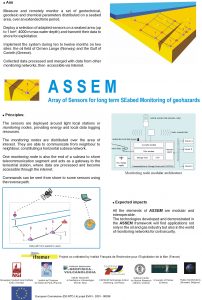
ASSEM: Array of sensors for long term seabed monitoring of geohazards

From 2002-01-01 to 2004-12-31

Total cost: 3.11M€ (EU contribution: 1.92M€)

Coordination: IFREMER

Objective

The project consisted in developing the means to measure and remotely monitor a set of geotechnical, geodesic and chemical parameters distributed on a seabed area, over an extended time period: The means was studied and realised to deploy a selection of adapted sensors on a seabed area (up to 1 km², 4000 m max water depth) and transmit their data to shore for exploitation. The system was implemented during ten months in the Corinth rift.

poster_assem Conference Tokyo April 2002

assem-under_water_technology_conference-tokyo-april2002

assem_project_2001


2001-2005 AEGIS (EU)

Ability Enlargement for Geophysicists and Information technology Specialists Gulf of Corinth project

Coordination: F. Cornet, IPGP

The objective of this project is to help fill the skill gap in Information Technology for personnel concerned with natural hazard mitigation as well as with hydrocarbon exploration and production. Indeed they all share a common interest in monitoring various field activities including seismicity, slow ground deformation, variations in pore pressure, temperature, electric resistivity, etc . But while efficient data collection techniques have been developed, data are still poorly exploited in part because the concerned personnel is too poorly educated in IT. The objective is to build up a training network combining academics and industry in order to establish an Earth Sciences group with strong expertise in modern Information Technologies including data compression, data mining, automatic signal processing and/or pattern recognition, as well as efficient multi-level Geographical Information Systems.

Description of work

The training action, which involves five partners from academia and two R&D centers from a world class company (Schlumberger) is two fold :
- Educate six specialists, at the Ph.D. and post-doc level, who will acquire a strong background in both Earth Sciences and Information Technology;
- Organize a number of training sessions for the six trainees together with experienced academics and industrial researchers from the various participating partners.

One Ph.D. concerns the application of data mining to the structuring and exploitation of the database to be developed for the Corinth Rift Laboratory, a European funded project dealing with the development of an in situ laboratory. This endeavor will generate a terabytes range database, which should be easily accessible to about 20 partners, scattered all over Europe. This data base will be used by another Ph.D. developing methods for the automatic analysis of seismic signals and by a post-doc concerned with efficient data compression by scattered wavelet technique for very long time series. The three other post-docs are end-users oriented and concerned by the development of Geographical Information Systems for Volcanic and seismic hazards mitigation and the development of an efficient database for the monitoring of hydrocarbon reservoirs and storage. They will benefit directly from other trainees?work. The first training session involves the presentation and practice of various existing efficient earth sciences databases. The following nine sessions are designed to raise the competency level of attendees in various specific IT topics.

2005-2007 3HAZ-Corinth (EU)

Coordination: P. Bernard

Full text of the project: 3HAZ

Objectives:

The goal of this project was to contribute to better measure, model, and predict the processes leading to earthquakes, landslides, submarine slides and tsunamis, and their effect in term of hazard. The target area is the rift of Corinth, well known for its exceptional activity with respect to these hazards. This work focused on the western end of the rift, close to the cities of Patras and Aigion, where the risk is highest.

3HAZ workpackages:

WP1 : Seismicity Monitoring and Modeling

WP2 : Long Term Deformation and Hazard

WP3: Short Term Tectonic Deformation

WP4: Aseismic transients and precursors

WP5: Landslides

WP6: Offshore slope failure and tsunamis

WP7: Sensor-innovation and demonstration

WP8: CRL information systems:Alarms, Webpage, and Data Base

WP9: Management