MOSAIC ITN-EJD Reference documents

Proposal acronym : MOSAIC
Draft proposal ID : SEP-210409852 (a final Proposal ID will be assigned as soon as the proposal is submitted)
Call : H2020-MSCA-ITN-2017
Type of action : MSCA-ITN-EJD
Topic : MSCA-ITN-2017
Call closure : 2017-01-10 17:00:00

You can review, edit and submit your proposal at any time from My Proposals tab in the Participant Portal.

Please note that the LEAR (Legal Entity Appointed Representative) of all organisations in this proposal will be notified about their involvement.

sep_usermanual

h2020-msca-itn-2017-part-b-document-1

h2020-msca-itn-2017-part-b-document-2

Example of the ITN Vertigo

MOSAIC ITN-EJD Partners


(1) Centre National de la Recherche Scientifique (CNRS) [PIC=999997930, VAT=FR40180089013]

Ecole Normale Supérieure PSL – Laboratoire de Géologie (UMR 8538) [PIC=999854758, VAT=FR 54 197 534 597, ERASMUS CODE=F PARIS087]

  • Frédérick Boudin (boudin@geologie.ens.fr)
  • Pierre Briole (briole@ens.fr) [Main contact]
  • Nicolas Chamot-Rooke (rooke@geologie.ens.fr)
  • Luce Fleitout (fleitout@geologie.ens.fr)
  • Hélène Lyon-Caen (helene.lyon-caen@ens.fr)
  • Alexis Rigo (alexis.rigo@ens.fr)
  • Mathieu Rodriguez (rodriguez@geologie.ens.fr)

University of La Rochelle (ULR) – LIENS (UMR 7266) [PIC=999846804, VAT=FR 21191700.327, ERASMUS CODE=F LA-ROCH08]

  • Valérie Ballu (valerie.ballu@univ-lr.fr) [Main contact]
  • Guy Woppelmann (guy.woppelmann@univ-lr.fr)

University Cote d’Azur (UCA) – (UMR 7329) [PIC=920248410=, ERASMUS CODE=F NICE01]

  • Anne Deschamps (deschamps@geoazur.unice.fr)
  • Lucie Rolland (lrolland@geoazur.unice.fr)
  • Anthony Sladen (sladen@geoazur.unice.fr) [Main contact]

University of Strasbourg (UNISTRA) – EOST (UMR 7516) [PIC=996569950, VAT=FR44130005457, ERASMUS CODE=F STRASBO48]

  • Jacques Hinderer (jacques.hinderer@unistra.fr)
  • Frédéric Masson (frederic.masson@unistra.fr) [Main contact]


(2) National Observatory of Athens (NOA) [PIC=999653677, VAT=EL090050779]

  • Konstantinos Chousianitis (chousianitis@noa.gr)
  • Panagiotis Elias (pelias@noa.gr)
  • Athanassios Ganas (aganas@noa.gr) [Main contact]
  • Dimitrios Katsanos (katsanos@noa.gr)
  • Adrianos Retalis (adrianr@meteo.noa.gr)
  • Nikos Roukounakis (nrouk@noa.gr)
  • LEAR: Olia Lazaridou (o.lazaridou@noa.gr)


(3) Harokopio University of Athens (HUA) [PIC=999858929, VAT=099075404, ERASMUS CODE=G KALLITH01]

  • Issaak Parcharidis (parchar.hua.gr) [Main contact]
  • Dora Perrou (dperrou@hua.gr)
  • LEAR: Demosthenes Panagiotakos (vice-rector of Harokopio University)


(4) National Kapodistrian University of Athens (NKUA) [PIC=999643007, VAT=EL090145420, ERASMUS CODE= G ATHINE01]

  • Stylianos Chailas (schailas@geol.uoa.gr)
  • Paraskevi Nomikou (evinom@geol.uoa.gr)
  • Vassilis Sakkas (vsakkas@geol.uoa.gr) [Main contact]
  • Andreas Tzanis (atzanis@geol.uoa.gr)
  • Nikos Voulgaris (voulgaris@geol.uoa.gr)


(5) University of Patras (UPAT) [PIC=999894528, VAT=EL998219694, ERASMUS CODE=G PATRA01]


(6) Charles University Prague (CUP) [PIC=999923434, VAT=CZ00216208, ERASMUS CODE=CZ PRAHA07]

  • Ondřej Čadek (oc@karel.troja.mff.cuni.cz)
  • František Gallovič (gallovic@karel.troja.mff.cuni.cz) [Main contact]
  • Jacub Kostelecky (jakub.kostelecky@pecny.cz)
  • Jan Kostelecky (kost@fsv.cvut.cz)
  • Vladimir Plicka (vp@karel.troja.mff.cuni.cz)
  • Jiri Zahradnik (jz@karel.troja.mff.cuni.cz)


(7) National Institute of Gephysics, Geodesy and Geography, Bulgarian Academy of sciences, Sofia (NIGGG-BAS) [PIC=974642324, VAT=BG175905823] (& University of Architecture, Civil Engineering and Geodesy, Sofia (UASG) [PIC=999871151, VAT=BG000670616, ERASMUS CODE=BG SOFIA04])

  • Dimitar Dimitrov (clgdimi@bas.bg)
  • Ivan Georgiev (ivan@bas.bg)
  • Maya Ilieva (m_b_ilieva@abv.bg) [Main contact]


(8) Istituto Nazionale di Geofisica e Vulcanologia, Rome (INGV) [PIC=999472675, VAT=IT06838821004]

  • Matteo Albano (matteo.albano@ingv.it)
  • Antonio Avallone (antonio.avallone@ingv.it)
  • Marco Anzidei (marco.anzidei@ingv.it) [Main contact]
  • Christian Bignami (christian.bignami@ingv.it)
  • Antonio Montuori (antonio.montuori@ingv.it)
  • Marco Moro (marco.moro@ingv.it)
  • Marco Polcari (marco.polcari@ingv.it)
  • Enrico Serpelloni (enrico.serpelloni@ingv.it)
  • Salvatore Stramondo (salvatore.stramondo@ingv.it)


(9) University Federico II Naples (UNINA) [PIC=999976590, VAT=IT00876220633, ERASMUS CODE=I NAPOLI01] RISSC-LAB

  • Antonio Emolo (antonio.emolo@unina.it)
  • Gaetano Festa (gaetano.festa@na.infn.it)
  • Sonia Sorrentino (sorrentin@fisica.unina.it)
  • Aldo Zollo (aldo.zollo@unina.it) [Main contact]

The EPOS NFOs

In the initial phase of EPOS IP, seven NFO nodes are linked in the TCS:

  • Alto Tiberina Observatory (Italy) [TABOO]
  • Irpinia Observatory (Italy)
  • Corinth Rift Observatory (Greece) [NFO CRL]
  • South Iceland Seismic Zone (Iceland)
  • Valais Observatory (Switzerland)
  • Marmara sea GEO supersite (Turkey) [MARSITE]
  • Vrancea Observatory (Romania)

[wpgmza id= »10″]


Glossary

Understanding EU, EPOS and other sabir

EPOS, the EC and several EU institutions are using a huge number of acronyms and expressions. Below is a list of some of them. You may also have a look at the EPOS glossary.

A

API: Application Programming Interface

AUV: Autonomous Underwater Vehicle

B

BGR: Board Of Governamental Representatives

C

CERIF: Common European Research Infrastructure Format [Learn more]

COMET: Centre for Observation and Modelling of Earthquakes, Volcanoes and tectonics [Learn more]

COPERNICUS: European Programme for the establishment of a European capacity for Earth Observation [Learn more]

CSEP: Collaboratory for the Study of Earthquake Predictability [Learn more]

D

dataless: same as « metadata »

DDSS: Data, Data products, Software and Services [Learn more]

DEM: Digital Elevation Model

DO: Digital Object

DOI: Digital Object Identifier [Learn more]. Description of the CRL d.o.i.


E

Earthcube: [Learn more]

EC: European Commission

ECO: Executive and Coordination Office

EEW: Earthquake Early Warning

EEWS: Earthquake Early Warning System

EFEHR: European Facilities for Earthquake Hazard & Risk

EGDI: EuroSurveys One Geology Europe [Learn more]

EGU: European Geosciences Union [Learn more]

EIDA: European Integrated Data Archive [Learn more]

EMSC: Euro-Med Seismological Centre [Learn more]

EPN: EUREF Permanent Network [Learn more]

EPOS: European Plate Observing System

EPOS-IP: EPOS Implementation Phase

EPOS-PP: EPOS Preparatory Phase

EPOSAR

ERIC: European Research Infrastructure Consortium

ESA: European Space Agency

ESFRI: European Strategy Forum on Research Infrastructures [Learn more]

ESRIN:

EUREF:

F

FUTUREVOLC:

G

GA: General Assembly

GDM

GEO: Group on Earth Observations [Learn more]

GEP-TEP:

GNSS:

GPS:

GPS84:

H

HEPOS

HELPOS

HR: High resolution

I

ICS: Integrated Core Services [Learn more]

ICS-C: ICS-Central hub

ICS-D: Distributed Integrated Core Services

ICT: Information & Communication Technology

InSAR:

INSPIRE: Infrastructure for Spatial Information in Europe [Learn more]

INTERMAGNET

IPR: Intellectual Property Rights

ISO

IT: Information Technologies

ITRF: International Terrestrial Reference Frame

IUGS/CGI:

J


K


L


M

MEDSUV: Mediterranean Supersite Volcanoes

MOD

N

NFO: Near Fault Observatory

NRI: National Research Infrastructures [Lear more]

O

OBS: Ocean Bottom Seismometer

OEF: Operational Earthquake Forecasting

OGC:

ORFEUS: Observatories and Research Facilities for European Seismology

P

PDB: Project Development Board

Q

R

RESIF:

RIDE: Research Infrasctructure Database for EPOS [Learn more]

RINEX:

S

SAR: Synthetic Aperture Radar

SCB: Service Coordination Board

T

TCS: Thematic Core Services [Learn more]

TNS: Trans National Access

TNRI: Trans-national Research Infrastructures

U

UNAVCO:

V

VERCE

VO: Volcano Observatory

VRI: Volcano Research Institution

W

W3C

X


Y


Z

Others

3D-Def


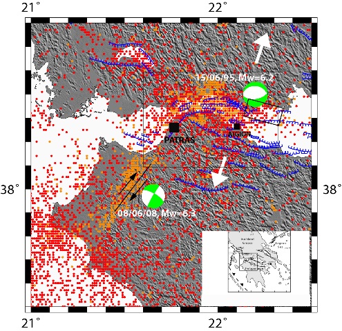
Mw=6.4 June 8, 2008 Movri earthquake

This earthquake ruptured 30 km of a NNE right lateral strike slip fault south of the city of Patras. No rupture was observed at the surface and slip is concentrated between 25 to 10 km depth.

patras_web_g

1964-2009 seismicity recorded by the National Observatory of Athens (red dots before 08/06/08, orange dots after)

Geodetic measurement of an already mesured network in the area has been performed just after the earthquake. OASP, University of Patras, ITSAK, university of Athens and french team installed 15 seismological in the epicentral area in order, in particular, to monitor the northern part of the rupture area near the city of Patras.


Tsunami

From Panadopoulos et al., 2015 (Tsunamis Generated By Coastal And Submarine Landslides In The Mediterranean Sea, January 2007, DOI: 10.1007/978-1-4020-6512-5_43, In book: Submarine Mass Movements and Their Consequences, pp.415-422)

-373 1794 1861 1888 1963 1965 1984 1995 1996

image map example

 
Year Day Lat Long cause intensity
-373 winter 38 11 22 09 EL 5/9
1794 11/6 38 23 22 23 EL 3/5
1861 26/12 38 12 22 12   3(+)/5
1888 9/9 38 15 22 05   2/3
1963 7/2 38 12 22 12   4/7
1965 6/7 38 22 22 14 EL 3/5
1984 11/2 38 24   EL 3/4
1995 15/6 38 22 22 14 EL 2(+)/4
1996 1/1 38 15 22 07 GS 3(+)/5
Main characteristics of the events from Papadopoulos (2003). EL = earthquake landslide, ES = earthquake marine slide, GS=gravitative marine slide. Tsunami intensity estimated in the 6-grade Sieberg-Ambraseys scale and the 12-grade Papadopoulos and Imamura (2001) scale.

-373 – Helike

Large earthquake with subsidence of the coastal strip of the Helike city, triggering a high tsunami. The city inundated while ten Spartan ships which happened to be at anchor close by destroyed along with the city.

11 June 1794 – Galaxidi

According to an anonymous manuscript written in c.1796, a tsunami was caused by coastal slump due to a strong earthquake near Galaxidi.

26 December 1861 – Valimitika

A large (M6.6) earthquake caused surface-breaks 13 km long, soil liquefaction and a coastal subsidence. Five tsunami waves, possibly caused by the coastal subsidence, were observed immediately after the shock with wave heights up to ~2 m in the south and north coasts of Corinth Gulf. Some damage in port facilities, cultivated land, merchantships and
row-boats were reported from Aeghion, Valimitika, Galaxidi, Itea and Skala-Vitrinitza.

9 September 1888 – Galaxidi

Strong, destructive shock in Aeghion caused a moderate tsunami in Galaxidi. The tsunami possibly was caused by submarine slides that occurred offshore Aigion.

7 February 1963

Locally strong, destructive tsunami at both coasts of Corinth Gulf was generated by gravitative coastal and submarine sediment slump along the mouth of Salmenikos river. Two persons killed, twelve injured, while destruction was reported in houses, cultivated land, fishing-boats and vessels.

6 July 1965 – Eratini

Strong (M=6.5) earthquake. Coastal landslide at Eratini caused a local tsunami as high as 3 m. One persondrowned and some damage was caused.

11 February 1984 – Sergoula

Moderate (M=5.5) earthquake triggering a local, moderate tsunami in Sergoula beach due to a ~100 m long coastal landslide. Small boats moved ashore.

15 June 1995 – Aigion

Strong (M=6.1) earthquake. In Eratini a coastal strip of ~100 m length and ~10 m width along the local river mouth slumped in the sea as it occurred with the 1965 shock, causing a small tsunami. The sea retreat was of 0.5-1 m, while wave amplitude of 40-50 cm was observed. In Aigion, the wave was of ~1 m high.

1 January 1996

Coastal strip of width of ~20 m and length of several hundred meters submerged gravitatively causing strong sea-waves ~2 m high that attacked the coastline to the east of Aeghion, mainly the beach of Digeliotika. The sea disturbance continued for about two hours. The sea advanced inland for ~30 m, overtopped the coastal street and caused
little damage to houses and cultivated land. A thin sand sediment was left behind

1996-1998 CRLAB (EU)

CRLAB: A european test site for earthquake precursors and crustal activity: the gulf of Corinth, Greece

Project ID: ENV4960276 (FP4)

From 1996-05-01 to 1998-09-30
Coordinated by: P. Bernard, IPGP

Objective