- 25 October 2018 M=6.8 Zakynthos
- 17 November 2015 M=6.4 Lefkada
- 1 July 2009 M=6.4 Crete
- 14 February 2008 M=6.9 Methoni
- 15 June 1995 M=6.2 Aigion
- 17 January 1983 M=7.2 Cephalonia
- 24 February 1981 M=6.7 Corinth
- 6 July 1965 M=6.3 Eratini-Galaxidi
- 7 February 1963 landslide Aigion
- 12 August 1953, M=7.2 Cephalonia
- 22 April 1948 M=6.5 Ionian sea
- 22 April 1928 M=6 Corinth
- 4 February 1867, M=7.4 Cephalonia
- 20 September 1867 M=7.1 Mani
- 6 January 1821 M=6.5 Ionian sea
- 29 December 1820 M=6.9 Zakynthos
- 14 May 1748 M=6.8 Corinth & Patras gulf
- 20 February 1743 M=6.8 Corfu
- 5 November 1633 M=6.9 Zakynthos
- 5 May 1622 M=6.6 Zakynthos
- April 551 M=7.1 Etolia
- 21 July 365 M=8 Crete
- -373 M=7.3 Corinth & Patras gulf
- June -426 M=7.1 Corinth & Patras gulf
Auteur/autrice : Pierre Briole
CRL portal facts 2017-2019
The statistics below are those of early november 2019
Click on the figures to enlarge

Figure 1. Daily number of visitors. The peaks are in september (during the CRLSchools) and in june (during the coordination meetings of the NFO).

Figure 2. Monthly number of visitors.
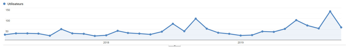
Figure 3. Evolution of the monthly number of returning visitors. The returning visitors represent 16.9% of the total number of visitors. Not considering the peaks of June and September (see Fig. 1), there is a positive long term trend passing from ~30 returning visitors/month in early 2017 to ~60 returning visitors/month in late 2019. The present (november 2019) 60/month might be a reasonably good measurement of the current number of routine users of data and products distributed through the CRL web portal (see pages most visited in Fig. 5).
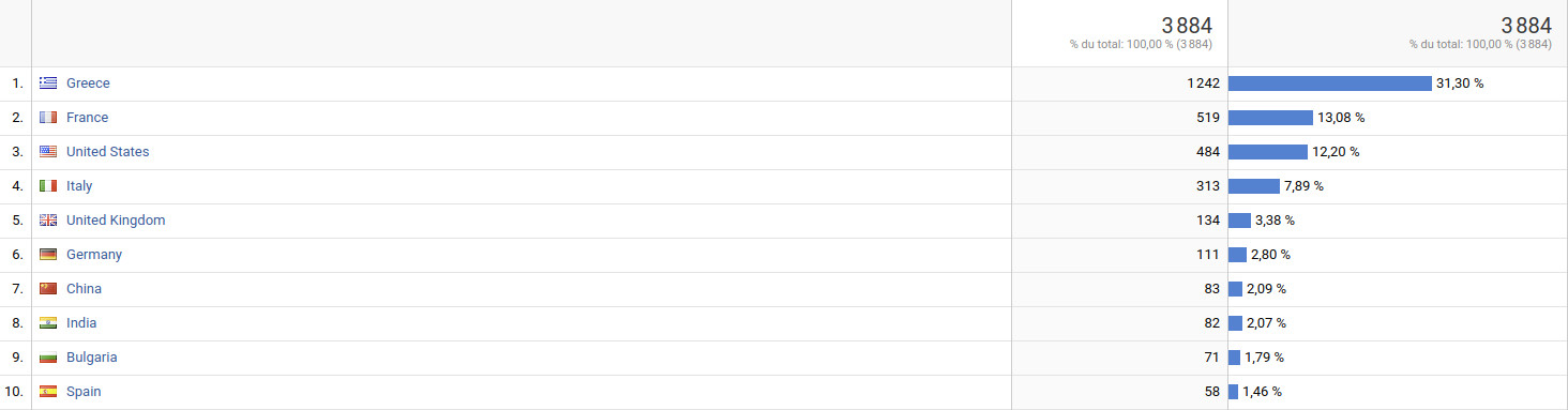
Figure 4. Country of the visitor. Greece is by far the top user of the CRL NFO web portal.
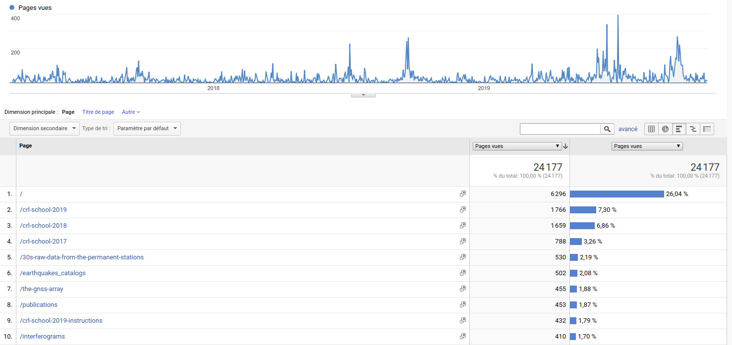
Figure 5. Pages most visites. The home page http://crlab.eu is the most visited with 26%. The three CRLSchools 2019, 2018 and 2017 gather in total 17.4%. The data/products pages most visited are those with 30s GNSS data, earthquakes catalogs, and interferograms.

Figure 6. Duration of the session. Apart the very short visits, the peak visit time is in the range 3-10mn.
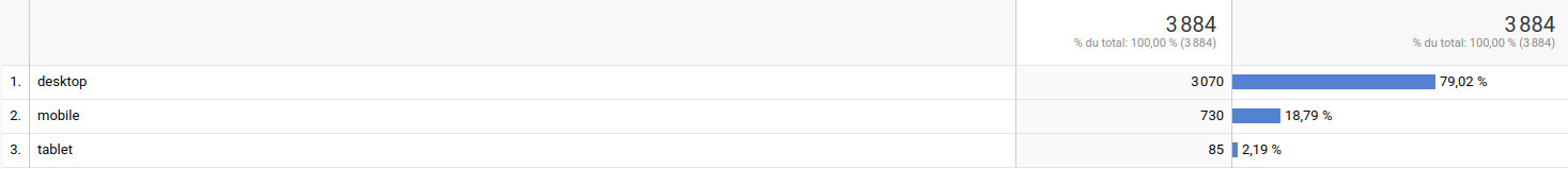
Figure 7. Type of interface. The CRL portal is compatible with smartphones and tablets. This is useful in particular to navigate whith the GPS of the smartphone to the stations in the field (see for example here for navigation to the seismic stations). The connections with smartphones account currently for ~19%.
CRL coordination meeting 2019
National and Kapodistrian University of Athens, June 19, 2019
Download report version 20191025a
Download minutes version 20191025a
Programme
- (A) 10:00-10:10 Welcome by the rector office of the NKUA
- (B) 10:20-10:30 Brief overview of the activity of the Observatory from June 2018 to June 2019 and introduction of the working programme of the day
- (C) 10:30-11:15 Field and telemetry infrastructure
- (D) 11:15-11:45 Raw data management & data/products
- (E) 11:45-12:00 Break
- (F) 12:00-12:45 Products workflow and management. Distribution of tasks abong partners for the various data processings, quality control (internal and cross-quality-control within the team)
- (G) 12:45-13:30 Web portal, interface(s) for communication, data and products, compliance with the EPOS formats for data and products
- (H) 13:30-14:30 Lunch break
- (I) 14:30-15:15 Governance and funding of the Observatory, scientific council, administrative issues
- (J) 15:15-16:00 Students exchanges among partners universities, educational and outreach component of the Observatory
- (K) 16:00-16:30 Conclusions and planned actions for the fortcoming months and until the June 2020 meeting
Other supporting documents
Direct link to files repository
GPS Itea
Free software and educational resources
Free software distributed by the space agencies
- ESA SNAP package
- CNES OrfeoToolBox
Free software useful at CRL for mapping
On-line GNSS processing resources
- NASA-JPL GIPSY processing on line
- IGN PPP processing on line processing
Free and educational sofware for remote sensing
- ESA educational page
Free and educational software for seismology
- SeisGram2K (by A. Lomax)
- Pytheas (by Spingos and Kaviris, 2019)
- IRIS educational pages
- EDUMED data center and tools
Free programming software
The CRL GitHub
CRL School 2019
The school is scheduled from Friday September 20 to Tuesday September 24.
Like for 2017 and 2018 this School will be partly supported by the European Geosciences Union.
The final programme (20190816) of the CRL School 2019
You can find Instructions for the trainees here (updated continuously)
Find you way to the School:
- The first day the course will begin at 13:30 at the 1st floor building B of the department of Physics of the University of Patras
- Akti Hotel, Nafpaktos
- Afroditi Hotel, Nafpaktos
- Nafpaktia Conference room, Nafpaktos
- Helike fault location, (38°12’57.1″N 22°06’49.6″E)
Press Release for the School:
- Announcement in press
- Dissemination from the National Observatory of Athens
- Press Release disseminated through the Municipality of Nafpaktos
Call for students for the CRL School 2019. In Greek.
Presentations (in powerpoint or PDF format):
FTP site with the presentations
Diffusion of the seismobox in the hellenic schools (video by Fotis Danaskos)
Friday 20 September
- Pierre Briole, The geodetic monitoring of the Corinth rift observatory with GPS and SAR interferometry, PPT
Saturday 21 September
Sunday 22 September
- Pierre Briole, Hand-on the GIPSY software for GNSS processing of the data acquired yesterday, PPT
Monday 21 September
Tuesday 22 September
Photos of the CRLSchool2019
Coordination meeting 2019
The coordination meeting 2019 is scheduled on June xx (fill Doodle here) in Athens. More details about the meeting place and timing will be available soon.
Reference documents:
- Minutes of the coordination meeting 2018 (Patras, June 12, 2018)
- Support requested for running the Observatory in 2019 and EPOS DDSS list
Preliminary program of the 2019 coordination meeting (available soon)
CEOS Disaster working group meetings
« The space component of the monitoring system in the Corinth Rift Near Fault Observatory » presented by P. Elias, on behalf of the CRL team, on March 6, 2019 at the 11th meeting of the working group on disasters of the Committee on Earth Observation Satellites«
« Studying moderate/strong seismic deformation events with Geohazards TEP – An overview of 2018 » presented by S. Valkaniotis on March 6, 2019 at the 11th meeting of the working group on disasters of the Committee on Earth Observation Satellites »
CRL School 2018
 Friday 21 September to Tuesday 25 September 2018
Download the programme (version of 23/08/2018)
Photos of the CRL School 2018
Field geology Video in the Corinth Gulf with Christian Beck during the School
Objectives of the CRL School 2018
-
- Gather students from various Greek and foreign universities working together at CRL and with different background
-
- Discover the research performed in Geophysics and Geology in the Rift of Corinth
-
- Learn more about SAR interferometry (SAR interferometry, the SENTINEL mission, the Geohazards Exploitation Platform (GEP) and its application to CRL)
-
- Learn more about GPS (theory, measurements in the field)
-
- Learn more about seismology (with didactic tools) and learn more about the seismicity in the Corinth Rift
-
- Learn more about sea, sea level, tsunami, …
-
- Go on board of a marine geophysics vessel
- Learn more about geotechical aspects of the seismic hazard in the area, the case of the Rio-Antirio bridge
Press Release for the School:
- Document disseminated through the municipality of Nafpaktos to the media
- Dissemination from the National Observatory of Athens
- Dissemination from the National & Kapodestrian University of Athens
Find you way to the School:
- The first day the course will begin at 13:30 at the 1st floor building B of the department of Physics of the University of Patras
- Akti Hotel, Nafpaktos
- Nafpaktia Conference room, Nafpaktos
GEP Courses material:
Friday 21 September
- Welcome to the CRL School 2018 (Vassilis Anastassopoulos, University of Patras)
- Seismic network of the Corinth Rift Laboratory and micro-seismicity in the last 20 years (Anne Deschamps, CNRS/Université Côte d’Azur/EduMed)
- Monitoring the deformation with GPS (Pierre Briole, CNRS/ENS/PSL)
- Monitoring the deformation with InSAR (Panagiotis Elias, Observatory of Athens)
- Coherence normalized difference for an earthquake with magnitude > 5 in GEP (Fabrice Brito, Terradue)
Saturday 22 September
- Tectonics, structural setting and tectono-sedimentary processes in the Corinth Rift (Haralambos Kranis, National and Kapodistrian University of Athens)
- How to build a half-graben (Jean-Arthur Olive, CNRS/ENS/PSL)
- Paleomagnetic studies of rotational deformations in western Greece at large and small geographic scale (Carlo Laj, ENS/PSL, Catherine Kissel, LSCE/CNRS/CEA, Massimo Mattei, Università Roma Tre)
- Paleomagnetic data in the Corinth and Megara basins (Greece) and comparison with existing GPS results (Massimo Mattei, Università Roma Tre)
- Corinth rift seismicity and applications (George Kaviris, NKUA)
- Deterministic seismic risk assessment with the use of stochastic simulation of strong ground motion taking into account site-effects and empirical vulnerability. case of the city of Aigion (Ioannis Kassaras, National and Kapodistrian University of Athens)
- Discussing the origin of rythmicity and/or cyclicity of few outcrops around Nafpaktos (Christian Beck, Université de Savoie)
Tuesday 25 September
- Presentation of the Seismology Laboratory, University of Patras (Anna Serpetsidaki, University of Patras)
- Structural monitoring and geometric control of the Rio-Antorio bridge (Akis Panagis, Gefyra)
- Recent sedimentary processes in the Gulf of Corinth. Seismic and aseismic turbidites (Spyros Sergiou, University of Patras)
- Location of the Heliki field trip. Where we pass under the highway
Video
Welcome talk by Vassilis Anastassopoulos